Maps are really important in genealogy, especially, when searching for ancestors in the American Colonies prior to 1850.
The Problem With North Carolina Records
While the horrendous handwriting and awful misspellings of family surnames make record searching tedious, it also doesn’t help that many early records have been lost, destroyed, or even misplaced.
Click here for a list of courthouse fires and record losses
North Carolina has had a number of courthouse disasters in which records were tragically lost forever. But another reason early records are so scarce, is because of its history of ever-changing counties! It’s not that early records do not exist, they just aren’t archived in the correct county!
The state of North Carolina (along with other Colonial states) prior to 1850 often had “fun” with establishing counties! North Carolina, in particular, is a headache with 100 counties, many of which have had numerous changes in boundaries and an additional 5 counties that were formed and later abolished! Some earlier counties didn’t even know where their boundaries started or ended (Tryon County for an example).
Click here to see an interactive map of changing North Carolina counties
When researching ancestors prior to 1850, it is important to identify a geological landmark in which they once lived, so that we can determine how many different counties covered that particular area. Once we identify all the possible counties, then we can dig into each of those county records!
My 4th great-grandfather’s property on Cedar Creek has been covered by 5 different counties: Tryon, Rutherford, Buncombe, Burke, (back to Rutherford), McDowell, and then back to Buncombe!
Records were supposed to transfer to the newly formed county, but that wasn’t always successful. Records pertaining to someone who lived in an area bordering another county (whose boundary lines were not well-defined) often caused confusion on where records were suppose to transfer to; especially, if the records had to be physically moved to a new courthouse. There is always that one box that gets left behind!
It is also important to remember that not every existing record is available to the public. There is a lot of records online, but much of it hasn’t been indexed yet for a quick search. It often requires a lot of browsing, scrolling and reading.
Whatever the reason records aren’t where we expect them to be, we can certainly take advantage of maps to help us try to locate them.
Rivers and Creeks were vital to every day life for our early ancestors. They traveled along them, they lived on them, they worked on them, and they built communities around them. Rivers and Creeks are the best types of landmarks to help us, not only to locate early records (with better defined keywords) in different counties but also learn more about their community to find families they likely traveled with to the new world.
While imaginary boundary lines were always changing, the landscape always remained the same.
Tryon County: Messy Boundaries
Tryon County, North Carolina no longer exists.
It was a county that covered a vast area of land which included parts of Indian territory (to the west) and parts of South Carolina.
Click here to see a list of modern day BOUNDARIES in which Tryon County covered
Many residents living near the border between North and South Carolina were a bit confused on which state they actually resided in, which likely complicated records (and probably taxes).
According to The Old Tryon County Genealogical Society website, The Southern Boundary of Tryon County, residents of Tryon County living on the border who considered themselves South Carolina residents may have records in Camden District, 96 District, or Craven County (SC).
To make matters even more complicated, Tryon County did not have a courthouse! According to Wikipedia (not my favorite source) and Journal of The American Revolution (a better source), states Christian Mauney (Mooney) conducted courthouse business on his land and “used his residence as a jail!”
Tryon was formed in 1768 and abolished in 1779 and then split into Rutherford and Lincoln County.
Here’s an idea of how many county changes occurred within the Old Tryon County territory:
In 1783, Rutherford County further defined their boundaries, giving much of Tryon County’s western territory back to the Indians. In 1791, Rutherford lost more of it’s western boundary to newly formed Buncombe County, but the boundary lines slightly changed back and forth between 1791-1793 (apparently nobody could make up their mind). In fact, a sliver portion of Rutherford County was briefly part of Burke County!
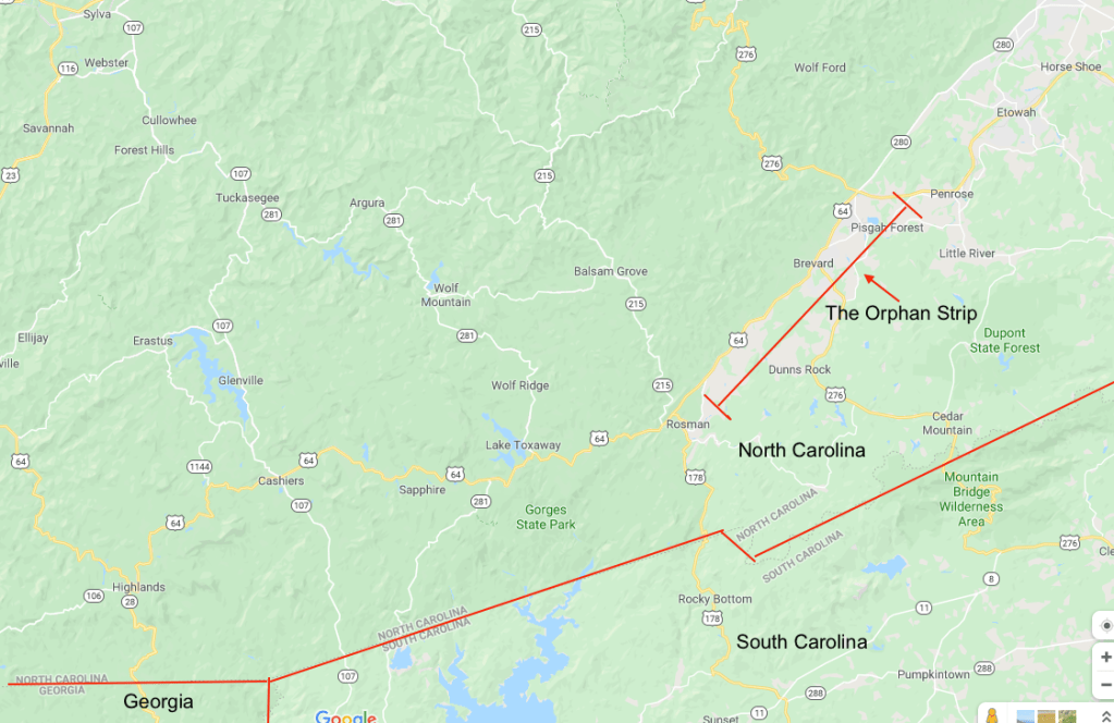
In 1812, what is now known as Transylvania County (formed from Henderson County) lies the historical and mostly forgotten Walton County of Georgia, a disputed strip of land that resulted in the WALTON WAR between Georgia, North and South Carolina. Basically, long story short, North Carolina took it back. Interestingly, the strip of land was known as the ORPHAN STRIP and it was considered to be a hideout for deserters and outlaws.

After that, the western portion of Old Tryon County expanded westward and formed counties like Hays, Macon, and Henderson, and Transylvania.
However, Rutherford and Lincoln County was the most complicated of county changes, for that in 1841, Cleveland County established itself smack dab in the middle between Rutherford and Lincoln County. Then, in 1844, Rutherford lost its north-western corner to McDowell County. In 1845, Lincoln County lost its southern half to Gaston County. Polk County formed in the northern-western corner of Rutherford County, just below Lake Lure, and in 1921, Buncombe county took over the north-western corner of Rutherford County from McDowell County. This kind of mess would make anyone’s brain spin!  mapofus.com
Finding A Map That Works!
My biggest challenge by far in Vess Genealogy has been trying to locate a map with North Carolina’s rivers and creeks! You would think it would be easy.
Of course, Google-maps is somewhat helpful, but it doesn’t show a lot of the creeks, especially, those mentioned on early land grants where most earlier settlers called home. Probably, because many of the creeks have dried up and disappeared along with history.
I need a map of Old Tryon County, but many maps of Tryon County are difficult to come by and those that are available are not detailed at all. The next best thing is to look at individual county maps, but again they are not as detailed and it makes it extremely difficult to see the full spectrum of an entire community of early settlers, especially, a community that has been broken up by different counties. Very frustrating!
However, I FINALLY stumbled upon a very useful map [below]. A map of the “Broad River Basin, which can be found on The University of North Carolina at Chapel Hill library’s website: North Carolina Maps.
I have NO IDEA how I found this website!!
Although this map is dated “1968,” it is exactly what I have been looking for! Not only does it show Rivers and Creeks, but also extends a little (just a little) outside the borders of Rutherford County, North Carolina. Basically, covering a good portion of Old Tryon County! Just want I needed!
Now We Are Getting Somewhere!
The first record of my earliest ancestor, Peter Vess, is an 1820 census record in Rutherford County, NC. After some research, I have determined that he was living on “Knobs Creek.”
Now that I finally have a decent map, I can use land records to determine nearby neighbors and begin to identify families who may have connections with him.
As of right now, I have complied a list of 19 land owners on and near Knobs Creek between 1775-1820. One by one, I am reviewing their land surveys.
Land survey’s (if they have one) tells me a lot!
1) Whose land they are joining (neighbor)
2) Whose properties their land touches (additional neighbors corners)
3) Witnesses (who are possibly close family or friends, some that don’t own land)
This is great, because I am finding more families who likely obtained land issued from Tryon County whose records were either lost, misplaced, or not available online yet.
However, I have just discovered that there are two Knob Creeks! I need to go back and review my research to determine which Knob Creek Peter Vess was likely living on in 1820. What is most exciting, is that the map I just recently found shows both Knob Creeks!
While reviewing land records, I have stumbled upon new interesting information which is beginning to form a somewhat crazy (or maybe not so crazy) new theory regarding my 4th great-grandfather’s origins! It will knock you off your feet!
